
124-E19-4
Displaying 1 - 4 of 4
| Catalog # | Name | Description | ||
|---|---|---|---|---|
| 1 | 1969.34 | Map | Copy of 1968 lithograph of Cedar Falls showing an aerial view of Cedar Falls. Color: TN,BK. There is a crease in the middle of the map running from top to bottom |
 |
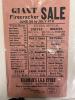
| 2 | 1970.47.5.36.12 | Handbill | Giant firecracker sale. Multiple creases in the paper. Rip from the paper in the middle left side. All corners and most edges are showing signs of color fading. Small brown stain on the middle back of the paper. |
 |
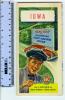
| 3 | 1975.4.49 | Map | Iowa Road Map. Distributed by Sinclair Gasoline. 1940 census used in population figures. On the front cover there is a man in a Sinclair cap pointing to the bottom of the map. The description he points to says "Look to SINCLAIR for better products and better service. In the background a red Ford is driving on a road with a billboard behind it saying "Road Map and Pictorial Sight Seeing Guide. |
 |
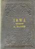
| 4 | 1980.44.1 | Map | Depicts various county boundaries and major cities and towns, quite detailed; map attached to and folds into hardbound brown cloth cover booklet; decorative engraved design on exterior cover, front cover with engraved gold leaf title, "IOWA, A. RANNEY"; interior front cover lists various maps, chart, books, and prints available from A. Ranney Publishing Col, "A. RANNEY, Publisher, 195 Broadway, N. Y." Map is torn at left side. The crease of the book shows discoloration. There are a few dusty colored spots on the front towards the edges. The inside of the book has some orangish spots towards the middle. |
 |