
124-E19-5
Displaying 1 - 2 of 2
| Catalog # | Name | Description | ||
|---|---|---|---|---|
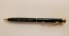
| 1 | 2020-20-21 | Pen | Pen from Chester J. Culver, Governor of Iowa. The pen is green and includes the state seal of Iowa on the back. |
 |
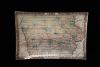
| 2 | 2022-25-12 | Plate | Plate with 1855 map of Iowa. The inspiration for this plate first came from a map of Iowa, drawn in 1855. The map was found in an antique store in North Carolina. The plate itself was created by Carol Kaas. Carol Kass, along with her husband, own a glass shop in New York. The owner of the map and Kass were both from Iowa. It was requested that Kass produce a plate from the 1855 map of Iowa. Since the map was created in 1855, there are some dissimilarities in counties/cities compared to the current state of Iowa. Kossuth and Bancroft were two separate counties in the 1855 map but now, Kossuth takes up the space of both counties - Bancroft no longer exists. Due to this, Kossuth is now Iowa's biggest county. Webster County, found on the 1855 map, is now two different counties - Webster and Hamilton. Ames, Iowa was not founded until 1864 so that city does not exist on this map. Lyon County, a county that exists now, was previously Buncombe County. All of this can be discovered when looking at the plate. |
 |