
155-D1-1
Displaying 1 - 16 of 16
| Catalog # | Name | Description | ||
|---|---|---|---|---|
| 1 | RSC-BN-4 | Map | Laminated 1970 map of Benton County school districts. Shows district boundaries and names. Likely used in school reorganization and consolidation. |
 |
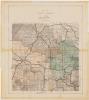
| 2 | RSC-CE-2 | Map | Laminated copy of a 1936 Cedar County map of school districts. Notes added in 1976 and 1983 using red ink. Shows 1936 school district boundaries with district and school names, some added later. Used in school district reorganization and consolidation. |
 |
| 3 | RSC-IC-1 | Map | Laminated map of Iowa County school districts, undated. Shows district names and boundaries. Likely used in school reorganization and consolidation. |
 |
| 4 | RSC-IC-1 | Map | A laminated copy of a 1904 Iowa County map. Notes added in the 1960s that detail school district boundaries and names. Used in reorganization/consolidation. |
 |
| 5 | RSC-IC-2 | Map | Laminated 1972 map of Iowa County school districts. Shows district names and boundaries. Likely used in school reorganization and consolidation. |
|
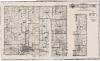
| 6 | RSC-JH-2 | Map | Laminated 1948 map of Johnson County, IA. Notes added in 1976 in red ink. The map shows townships, cities, and other features. Grid added in red ink shows school district boundaries. Notes added in red ink show the names of individual schools. Used in school district reorganization and consolidation. |
 |
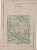
| 7 | RSC-JH-3 | Map | Laminated map of Johnson County, 1967. School districts and their boundaries printed in pink overlay over original transportation map. Likely used in school reorganization and consolidation efforts. |
 |
| 8 | RSC-JO-6 | Map | Laminated copy of a Jones County map, 1915. Shows school district boundaries and some names. Notes added in red ink, likely in the 1970s-1980s based on other maps from same donation. On the back is an updated 1926 map of Castle Grove Township showing the new boundaries. Used in school district reorganization and consolidation. |
") |
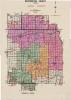
| 9 | RSC-JO-7 | Map | Laminated map of Jones County school districts, undated. Various districts are labelled and shaded in different colors. A handwritten note at the bottom reads "Exhibit B." Likely made in the 1970s-1980s based on other maps in the same donation. Used in school reorganization and consolidation efforts. |
 |
| 10 | RSC-LI-2 | Map | Laminated copy of a 1906 map of Maine Township, Linn County. Shows landowners and plats. Added in ink are the boundaries and names of local school districts. Used in school district reorganization and consolidation. |
 |
| 11 | RSC-LI-3 | Map | Laminated copy of a 1906 map of Marion Township, Linn County. Map is from 1983. Shows landowners, their land, cities, rivers, and schools/churches. Added markings indicate school district boundaries and the names of some schools. Used in school district reorganization and consolidation. |
 |
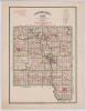
| 12 | RSC-LI-4 | Map | Laminated 1966 map of Linn County school districts. Includes some coverage of adjacent counties where school districts cross the county line. Likely used in school reorganization and consolidation. |
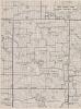 |
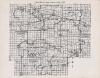
| 13 | RSC-LI-5 | Map | Laminated copy of a 1914 map of Linn County. School districts and their boundaries shown in green ink. Handwritten notes added in red ink. Notes likely date from late 1970s to early 1980s based on other maps in the same donation. Used in school reorganization and consolidation efforts. |
 |
| 14 | RSC-WA-1 | Map | Copy of a 1920 Washington County, IA map. Laminated. Used in reorganization/consolidation discussions. |
 |
| 15 | RSC-WA-2 | Map | Laminated map of Washington County, 1955. Map is a modified highway and transportation map with school districts added in red ink. Map has handwritten marks in green editing some districts. Used in school district reorganization and consolidation. |
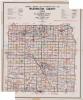 |
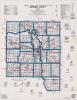
| 16 | RSC-WA-3 | Map | A map of Washington County, Iowa school districts, dated 1966. School districts and their boundaries are labelled in red, with three districts colored in. |
 |