
155-D1-2
Displaying 1 - 16 of 16
| Catalog # | Name | Description | ||
|---|---|---|---|---|
| 1 | RSC-HE-399 | Atlas | 1961 atlas of Henry County. Includes icons for schools, churches, and graveyards. Printed by R. C. Booth Enterprises, Harlan, Iowa. |
 |
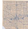
| 2 | RSC-MH-17 | Map | A Map of Mahaska County, dated July 1st, 1966. |
 |
| 3 | RSC-Platmap-1 | Map | A double-sided map of Wapello County, Iowa, dated 1875. The other side features plat maps of several Iowan communities: Russell in Lucas County, Scranton in Greene County, Tyrone in Marion County, Knoxville in Marion County, Ottumwa in Wapello County, and Jefferson in Greene County. |
 |
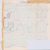
| 4 | RSC-Platmap-10 | Map | Large school district plat map focused on northeastern Iowa, particularly the area between Cedar Falls and Wellsburg, Iowa. Undated, but in context of original folder, dated 1961. Map shows boundaries for several districts, most importantly a proposed change to Dike, Iowa's school district and objectors who lived to the northwest of Dike. Originally in Butler County Box 3 Folder 29 |
 |
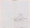
| 5 | RSC-Platmap-11 | Map | School district plat map for Waverly-Shell Rock Community School District. Undated, but in context of original folder, from 1963. |
 |
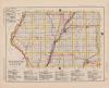
| 6 | RSC-Platmap-12 | Map | A 1912 map of Van Buren County and Wapello County, Iowa. From the Iowa Touring Atlas. Double-sided, one county to a side. Lists routes, towns, and places to buy gas or get a hotel room, also includes School locations. |
 |
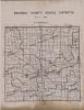
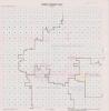
| 7 | RSC-Platmap-13 | Map | An Undated Platmap showing School Districts across multiple counties. Some plats and districts have hand-written notes added to them. |
 |
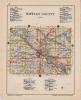
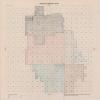
| 8 | RSC-Platmap-14 | Map | An Undated Platmap showing multiple counties. Centered on Oskaloosa, Iowa. |
 |
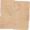
| 9 | RSC-Platmap-2 | Map | Hand-drawn map of area in northern Grundy County between Parkersburg, Iowa, and Dike, Iowa. Labelled "Appellee Exhibit 1 Parkersburg Community School Proposal," dated June 30, 1961. Shows boundaries of the various school districts involved, including the contested territory of Beaver Township No. 3, Beaver Township, No. 4, and Beaver Township, No. 5. Originally in Butler County Box 4 Folder 10 |
 |
| 10 | RSC-Platmap-3 | Map | A 1912 map of Pochantas County and Plymouth County, Iowa. From the Iowa Touring Atlas. Double-sided, one county to a side. Lists routes, towns, and places to buy gas or get a hotel room. |
 |
| 11 | RSC-Platmap-4 | Map | Hand-drawn map of an 8 square mile area in northern Iowa between Dike, Wellsburg, and Parkersburg. Undated, but from 1961 based on the original folder it was in. The map lists adult residents, the number of children, and whether they want to join Parkersburg Community School District, Dike Community School District, or if they are undecided. The map also lists some statistics about information like the number of tenents in the area or how many objectors to the consolidation plan there are. Some of these residents were previously in Beaver Township No. 3, Beaver Township No. 4, and Beaver Township No. 5 of Grundy County. Originally in Butler County Box 4 Folder 9 |
|
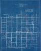
| 12 | RSC-Platmap-5 | Map | Map of a proposed Ackley School District, centered on Ackley, Iowa, dated June 1954. Map shows boundaries of proposed district, roads, tax districts, and other information. Has territory in 4 Iowa counties: Franklin, Hardin, Grundy, and Butler. Blueprint. Originally in Butler County Box 3 Folder 1 |
 |
| 13 | RSC-Platmap-6 | Map | School district map labelled "Ackley-Geneva Community Reorganization Map," undated. Shows boundaries for a potential school district centered on Ackley, Iowa. The district includes territory from 4 Iowa counties: Hardin, Franklin, Grundy, and Butler. Undated, but from between 1954 and 1961 based on inclusion with other materials from that time period. Originally in Butler County Box 3 Folder 1 |
 |
| 14 | RSC-Platmap-7 | Map | School district plat map for an area of northeastern Iowa, focused on the towns of Shell Rock and Waverly. Undated, but likely from 1957 based on original folder. The map shows a "Waverly-Shell Rock Community School District" and nearby districts. Several small districts have arrows that go from their area to a larger nearby area. Originally in Butler County Box 5 Folder 3 |
 |
| 15 | RSC-Platmap-8 | Map | School district plat map for Shell Rock Community School District and Waverly, Iowa's school district, undated. In context of original folder, from 1956-1957. Shows boundaries of the two school districts, with a focus on Shell Rock, including numbered sub-boundaries on the left side of Shell Rock. These numbers seem to line up with petitions in the original folder. Originally in Butler County Box 5 Folder 2 |
 |
| 16 | RSC-Platmap-9 | Map | School district plat map for Finchford Consolidated School District in Bremer County and Black Hawk County. Undated, but likely from 1957 based on original folder. The map has several internal boundaries added in pencil, some of which contain other markings. Originally in Butler County Box 5 Folder 3 |
 |