
155-A1-1
Displaying 1 - 3 of 3
| Catalog # | Name | Description | ||
|---|---|---|---|---|
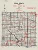
| 1 | RSC-BN-3 | Map | Laminated copy of a 1904 Benton County map with added handwritten notes. Has a black ink grid printed onto it, with the notes in red ink. Shows school districts and their names. Made in 1983 and used in school district reorganization and consolidation efforts. |
 |
| 2 | RSC-CE-3 | Map | Laminated 1967 map of Cedar County, Iowa. Shows school districts and community college districts for area in red ink. Likely used in school reorganization and consolidation. |
 |
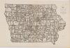
| 3 | RSC-IA-3 | Map | Iowa State Highway Commission map of Iowa, dated 1958. An unknown party overlaid a network of borders dividing the state into 359 sections. |
 |