
155-D1-5
Displaying 1 - 9 of 9
| Catalog # | Name | Description | ||
|---|---|---|---|---|
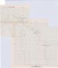
| 1 | RSC-AL-126 | Map | School district plat map for "Allamakee Community School District" in Allamakee County, Iowa. Map states it was "Approved - March 31, 1958." Shows added territory with notes. Used in school consolidation and reorganization. Originally in Allamakee County Box 3 Folder 3. |
 |
| 2 | RSC-AL-127 | Map | School district plat map for "Eastern Allamakee Community School District," in Allamakee County, Iowa. Map states it was "Approved - May 26, 1958." Includes notes on added territory. Used in school district consolidation and reorganization. Originally in Allamakee County Box 3 Folder 3 |
 |
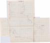
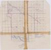
| 3 | RSC-CE-4 | Map | An undated partial plat map of Cedar County, Iowa. Covers sections of Dayton, Fairfield, Massilion, and Springfield Townships. Likely from the 1930s based on analysis of a 1930 plat book and other records. Likely used in school reorganization and consolidation, based on other maps in same donation. |
 |
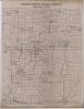
| 4 | RSC-KO-1 | Map | Keokuk County School Districts, September 1, 1966. |
 |
| 5 | RSC-KO-2 | Map | Keokuk County School Districts, September 1, 1966. |
 |
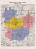
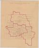
| 6 | RSC-MD-1 | Map | Madison County, Iowa School Districts, 1968. School districts marked out in red ink. |
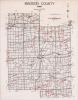 |
| 7 | RSC-MH-13 | Map | Existing School Districts Mahaska County, Jan. 1, 1956. Handwritten showing all school districts in Mahaska County, some areas outlined in red ink. |
 |
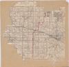
| 8 | RSC-PK-1 | Map | Polk County Map, dated 1955. Used in Rural School reorganization & Consolidated. |
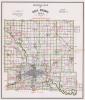 |
| 9 | RSC-PK-2 | Map | A platmap of Polk County, used in rural school reorganization & Consolidation. |
 |