|
6701 |
RSC-DU-57 |
Book |
Dubuque County Rural School Records, Teachers' Reports to the Superintendent, 1951-1952. Hardback, black covers, red spine and covers, bound with thread. Volume 56.
|
 |
|
6702 |
RSC-DU-58 |
Book |
Dubuque County Rural School Records, Teachers' Reports to the Superintendent, 1952-1953. Hardback, grey covers, green spine, bound with thread and fabric. Volume 57.
|
|
|
6703 |
RSC-DU-59 |
Book |
Dubuque County Rural School Records, Teachers' Reports to the Superintendent, 1953-1954. Hardback, blue covers and spine. Volume 58.
|
|
|
6704 |
RSC-DU-60 |
Book |
Dubuque County Rural School Records, Teachers' Reports to the Superintendent, 1954-1955. Hardback, blue covers and spine, bound with thread. Volume 59.
|
|
|
6705 |
RSC-DU-61 |
Book |
Dubuque County Rural School Records, Teachers' Reports to the Superintendent, 1955-1956. Hardback, blue covers and spine. Volume 60.
|
|
|
6706 |
RSC-DU-62 |
Book |
Dubuque County Rural School Records, Teachers' Reports to the Superintendent, 1956-1957. Hardback, blue covers and spine. Volume 61.
|
|
|
6707 |
RSC-DU-63 |
Book |
Dubuque County Rural School Records, Teachers' Reports to the Superintendent, 1957-1958. Hardback, blue covers and spine. Volume 62.
|
|
|
6708 |
RSC-DU-64 |
Book |
Dubuque County Rural School Records, Teachers' Reports to the Superintendent, 1958-1959. Hardback, blue covers and spine. Volume 63.
|
|
|
6709 |
RSC-DU-65 |
Book |
Dubuque County Rural School Records, Teachers' Reports to the Superintendent, 1959-1960. Hardback, blue covers and spine. Volume 64.
|
|
|
6710 |
RSC-DU-66 |
Book |
Dubuque County Rural School Records, Teachers' Reports to the Superintendent, 1960-1961. Hardback, blue covers and spine. Volume 65.
|
|
|
6711 |
RSC-DU-67 |
Book |
Dubuque County Rural School Records, Teachers' Reports to the Superintendent, 1961-1962. Hardback, blue covers and spine. Volume 66.
|
|
|
6712 |
RSC-DU-68 |
Book |
Dubuque County Rural School Records, Teachers' Reports to the Superintendent, 1962-1963. Hardback, blue covers and spine. Volume 67.
|
|
|
6713 |
RSC-DU-69 |
Book |
Dubuque County Rural School Records, Teachers' Reports to the Superintendent, 1963-1964. Hardback, blue covers and spines. Volume 68.
|
|
|
6714 |
RSC-DU-70 |
Book |
Dubuque County Rural School Records, Teachers' Reports to the Superintendent, 1964-1965. Hardback, blue covers and spine. Volume 69.
|
|
|
6715 |
RSC-DU-71 |
Book |
Dubuque County Rural School Records, Teachers' Reports to the Superintendent, 1965-1966. Hardback, blue covers and spine. Volume 70.
|
|
|
6716 |
RSC-DU-72 |
Book |
Dubuque County Rural School Records, Teachers' Reports to the Superintendent, 1930-1952. Hardback, black cover, red spine and corners, bound with thread and fabric. Volume 71.
|
|
|
6717 |
RSC-DU-73 |
Records |
Dubuque County Rural School Records, Reorganization and Consolidation Records, 1966, Dubuqe County Box 1, Folder 1
Attachments
|
|
|
6718 |
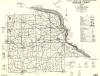
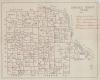
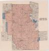
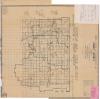
RSC-DU-74 |
Map |
General Highway and Transportation Map for Dubuque County, Iowa, dated 1954. Map used in school consolidation and reorganization.
|
 |
|
6719 |
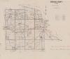
RSC-DU-75 |
Records |
Dubuque County Rural School Records, Reorganization and Consolidation Records, undated, Dubuqe County Box 1, Folder 3
Plat Books
|
|
|
6720 |
RSC-DU-76 |
Records |
Dubuque County Rural School Records, Reorganization and Consolidation Records, 1960, Dubuqe County Box 1, Folder 4
|
|
|
6721 |
RSC-DU-77 |
Records |
Dubuque County Rural School Records, Reorganization and Consolidation Records, 1960-1966, Dubuqe County Box 1, Folder 5
|
|
|
6722 |
RSC-DU-78 |
Records |
Dubuque County Rural School Records, Reorganization and Consolidation Records, 1963, Dubuqe County Box 1, Folder 6
Wilton Merger
|
|
|
6723 |
RSC-DU-79 |
Records |
Dubuque County Rural School Records, Reorganization and Consolidation Records, 1957-1966, Dubuqe County Box 1, Folder 7
Western Dubuque
|
|
|
6724 |
RSC-DU-80 |
Records |
Dubuque County Rural School Records, Reorganization and Consolidation Records,1966, Dubuqe County Box 1, Folder 8
Western Dubuque Attachments
|
|
|
6725 |
RSC-DU-81 |
Records |
Dubuque County Rural School Records, Reorganization and Consolidation Records, 1959, Dubuqe County Box 2, Folder 2
|
|
|
6726 |
RSC-DU-82 |
Records |
Dubuque County Rural School Records, Reorganization and Consolidation Records, 1960, Dubuqe County Box 2, Folder 3
|
|
|
6727 |
RSC-DU-83 |
Records |
Dubuque County Rural School Records, Reorganization and Consolidation Records, 1961-1962, Dubuqe County Box 2, Folder 4
|
|
|
6728 |
RSC-DU-84 |
Records |
Dubuque County Rural School Records, Reorganization and Consolidation Records, 1963-1964, Dubuqe County Box 2, Folder 5
|
|
|
6729 |
RSC-DU-85 |
Records |
Dubuque County Rural School Records, Reorganization and Consolidation Records, 1965-1966, Dubuqe County Box 2, Folder 6
|
|
|
6730 |
RSC-DU-86 |
Records |
Dubuque County Rural School Records, Teachers' Teaching Record, A-E, 1910-1979, Dubuqe County Box 5, Folder 1
|
|
|
6731 |
RSC-DU-87 |
Records |
Dubuque County Rural School Records, Teachers' Teaching Record, F-M, 1910-1979, Dubuqe County Box 5, Folder 2
|
|
|
6732 |
RSC-DU-88 |
Records |
Dubuque County Rural School Records, Teachers' Teaching Record, N-Z, 1910-1979, Dubuqe County Box 5, Folder 3
|
|
|
6733 |
RSC-DU-89 |
Records |
Dubuque County Rural School Records, Eighth Grade Examinations, 1948-1954, Dubuqe County Box 5, Folder 4
|
|
|
6734 |
RSC-DU-90 |
Records |
Dubuque County Rural School Records, Eighth Grade Examination Records, 1955-1968, Dubuqe County Box 5, Folder 5
|
|
|
6735 |
RSC-DU-91 |
Records |
Dubuque County Rural School Records,County School Census, 1952, Dubuqe County Box 6, Folder 1
|
|
|
6736 |
RSC-DU-92 |
Records |
Dubuque County Rural School Records,County School Census, 1954, Dubuqe County Box 6, Folder 2
|
|
|
6737 |
RSC-DU-93 |
Records |
Dubuque County Rural School Records, County School Census, 1956, Dubuqe County Box 6, Folder 3
|
|
|
6738 |
RSC-DU-94 |
Records |
Dubuque County Rural School Records, County School Census, 1958, Dubuqe County Box 6, Folder 4
|
|
|
6739 |
RSC-DU-95 |
Records |
Dubuque County Rural School Records, County School Census, 1960, Dubuqe County Box 6, Folder 5
|
|
|
6740 |
RSC-DU-96 |
Records |
Dubuque County Rural School Records, County School Census, 1962, Dubuqe County Box 7, Folder 1
|
|
|
6741 |
RSC-DU-97 |
Records |
Dubuque County Rural School Records, County School Census, 1964, Dubuqe County Box 7, Folder 2
|
|
|
6742 |
RSC-DU-98 |
Records |
Dubuque County Rural School Records, County School Census, 1966, Dubuqe County Box 7, Folder 3
|
|
|
6743 |
RSC-DU-99 |
Records |
Dubuque County Rural School Records, Teachers' Checks, 1926-1944, Dubuqe County Box 7, Folder 4
Independent School District of Flanagan
|
|
|
6744 |
RSC-DU-100 |
Map |
Westerm Dubuque County Community School District, County Board Election Areas For Western Dubuque
|
 |
|
6745 |
RSC-DU-101 |
Map |
Official Map of Delaware County, Iowa. Exhibit C of Dubuque County Plan. A Map of Delaware County used in the reorganization and consolidation of Schools in Dubuque County.
|
 |
|
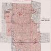
6746 |
RSC-DU-102 |
Map |
General Highway and Transportation Map Clayton County, Iowa. Hand drawn and labeled on the map are the school districts. Used in the reorganization and consolidation of Dubuque County.
|
 |
|
6747 |
RSC-DU-103 |
Map |
A Map of Jackson County on which the Schools have been circled in ink. Used in the reorganization and consolidation of schools in Dubuque County.
|
 |
|
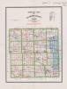
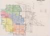
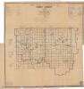
6748 |
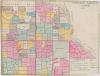
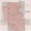
RSC-DU-104 |
Map |
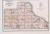
A Map of Dubuque County, with the different School districts colored to distinguish them from each other. Used in Reorganization and Consolidation of Schools in Dubuque County.
|
 |
|
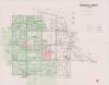
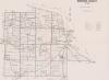
6749 |
RSC-DU-105 |
Map |
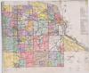
A printed Map of Dubuque County, showing School Districts. Used in Reorganization and Consolidation.
|
 |
|
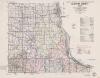
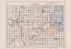
6750 |
RSC-DU-106 |
Map |
A printed map of Dubuque County. Official Map of Dubuque County, Iowa. All of the operational rural schools are circled. Used in Reorganization and Consolidation of schools in Dubuque County.
|
 |
|
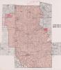
6751 |
RSC-DU-107 |
Map |
A map of Dubuque County showing Public and Parochial School attendance 1956-1957. Used in Reorganization & Consolidation of rural schools in Dubuque County.
|
 |
|
6752 |
RSC-DU-108 |
Map |
A map of Dubuque County showing Public and Parochial School attendance 1956-1957. Used in Reorganization & Consolidation of rural schools in Dubuque County.
|
|
|
6753 |
RSC-DU-109 |
Map |
A map of Dubuque County. Hand drawn, colored in to show school districts, several from outside Dubuque County are shown. Used in Reorganization & Consolidation of rural schools in Dubuque County.
|
 |
|
6754 |
RSC-DU-110 |
Map |
A map of Western Dubuque County Community Schools District. Other school districts added in red pen. Used in Reorganization & Consolidation of rural schools in Dubuque County.
|
 |
|
6755 |
RSC-DU-111 |
Map |
A map of Dubuque County. Hand drawn and colored on the map of are school districts, with school districts outside Dubuque County. Used in Reorganization & Consolidation of rural schools in Dubuque County.
|
 |
|
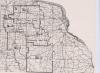
6756 |
RSC-DU-112 |
Map |
A map of Dubuque County from 1942. It shows closed and operating rural schools in red ink, with school attendance also listed.
|
 |
|
6757 |
RSC-DU-113 |
Map |
A map of Dubuque County from 1942. It shows rural school districts colored in on the map, showing Township schools, Rural Independent schools and incorporated Town Schools.
|
 |
|
6758 |
RSC-DU-114 |
Map |
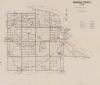
A map of Dubuque County , shows four school districts throughout Dubuque county. Used In Rural School Reorganization & Consolidation.
|
 |
|
6759 |
RSC-DU-115 |
Map |
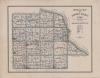
A map of Dubuque County showing the rural school districts colored in.
|
 |
|
6760 |
RSC-DU-116 |
Map |
A map of Western Dubuque County Community School District with some areas shaded blue. Used in Reorganization & Consolidation
|
 |
|
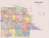
6761 |
RSC-DU-117 |
Map |
A map of Western Dubuque County Community School District dated 1962. From Office of the Superintendant of Dubuque County Schools. Used in Reorganization & Consolidation.
|
 |
|
6762 |
RSC-DU-118 |
Map |
A map of Dubuque County Iowa showing the school Districts. Some of the school names have been underlined in red ink, and the name and part of the outline of the school district of Vernon has been added to the map. Used in reorganization and consolidation of rural schools in Dubuque County.
|
 |
|
6763 |
RSC-DU-119 |
Records |
Dubuque County Rural School Records,Superintendent's Record of Teacher's Service, 1954
Dubuque County, Washington Township, #1 Franklin
|
|
|
6764 |
RSC-DU-120 |
Booklet |
Dubuque County Rural School Records, Class Reunion of Franklin School, July 22, 1984
Dubuque County, Washington Township, #1 Franklin
|
|
|
6765 |
RSC-EM-1 |
Book |
Board of Education minutes from High Lake Township, Emmett County, Iowa. Covers 1934-1966. Minutes deal with teacher salaries, district expenses, and other topics.
Materials interleaved in book. Volume 1
|
|
|
6766 |
RSC-EM-2 |
Book |
Board of Education financial record book and meeting notes for Emmett Township, Emmett County, Iowa. Covers 1917-1936. Published by Matt Parrott & Sons Company.
Items interleaved in book. Volume 2. Black leather spine and brown fabric cover.
|
|
|
6767 |
RSC-EM-3 |
Book |
Board of Education financial record book for High Lake Township, Emmett County, Iowa. Covers 1917-1927. Published by Matt Parrott & Sons Company. Form 61-3.
Items interleaved in book. Volume 3. Black leather spine and gray fabric cover.
|
|
|
6768 |
RSC-EM-4 |
Book |
Board of Education financial record book for High Lake Township, Emmett County, Iowa. Covers 1917-1929. Published by Matt Parrott & Sons Company. Form 61-3.
Items interleaved in book. Volume 4. Black leather spine and gray fabric cover.
|
|
|
6769 |
RSC-EM-5 |
Book |
Board of Education financial record book and board meeting minutes for Twelve Mile Lake Township, Emmett County, Iowa. Covers 1956-1966. Published by Klipto Loose Leaf Co.
Items interleaved in book. Volume 5. Green fabric cover and red plastic spiral binding.
|
|
|
6770 |
RSC-EM-6 |
Documents |
Emmett County school district reorganization and consolidation records, 1925-1951.
21 items in total.
|
|
|
6771 |
RSC-EM-7 |
Documents |
Emmett County rural school records, 1946-1960. Consolidation and reorganization records related to Lincoln Central.
33 items in total.
|
|
|
6772 |
RSC-EM-8 |
Documents |
Emmett County school documents, 1958-1959. Ballots and affidavits related to the Lincoln Center Community School District.
86 items in total.
|
|
|
6773 |
RSC-EM-9 |
Documents |
Emmett County school documents, 1958. Almost all are petitions related to formation of Lincoln Central Community School District.
35 items in total.
|
|
|
6774 |
RSC-EM-10 |
Documents |
Emmett County school documents, 1947. Items deal with Swan Lake Township and reorganization/consolidation of the local school district. Includes related petitions/objections.
5 items in total.
|
|
|
6775 |
RSC-EM-11 |
Documents |
Emmett County school documents, 1952-1953. Related to reorganization/consolidation of Gruver Independent School District.
7 items in total.
|
|
|
6776 |
RSC-EM-12 |
Microfilm |
Emmett County education records on microfilm. Reel 1
Contents:
County Board of Education Minutes, 1883-1901
Teachers' Examination Records, 1882-1895
High School Normal Training Record, 1903-1927
School Officer and Teacher Record, 1891-1902
School Officer Record, 1903-1911
School Officer and Teacher Record, 1902-1916
Record of Teachers' Certificates, 1907-1927
Record of Teachers' Certificates, 1926-1951
School Officer and Teacher Records, 1936-1937
Town School Officer and Teacher Record, 1928-1975
Town School Officer and Teacher Record, 1928-1933
School Officer and Teacher Record, 1928-1946
|
|
|
6777 |
RSC-EM-13 |
Microfilm |
Emmett County educational records on microfilm. Reel 2
Contents:
School Officer and Teacher Record, 1928-1946
High School Normal Training Record, 1913-1938
Pupils' Permanent Record, 1921-1945
Teachers' Reports to the Superintendent, Center Township, 1919-1937
Teachers' Reports to the Superintendent, Center Township, 1943-1945
Teachers' Reports to the Superintendent, Denmark Township, 1919-1949
School Registers, Ellsworth Township #1, 1923-1934
School Registers, Ellsworth Township #2, 1897-1901
|
|
|
6778 |
RSC-EM-14 |
Microfilm |
Emmett County educational records on microfim, Reel 3.
Note: Listed year ranges are not all inclusive - most have gaps.
Contents:
School Registers, Ellsworth Township #2, 1901-1914
School Registers, Ellsworth Township #2, 1943-1947
Teachers' Reports to the Superintendent, Ellsworth Township, 1919-1947
School Registers, Ellsworth Township, undated
School Registers, Ellsworth Township, 1919-1945
Teachers' Reports to the Superintendent, Ellsworth Township, 1919-1964
School Registers, High Lake Township #3, 1949-1953
School Registers, High Lake Township #4, 1908-1920
School Registers, High Lake Township #4, 1942-1953
School Registers, High Lake Township, 1898-1902
School Registers, High Lake Township #6, 1922-1952
School Registers, High Lake Township #10, 1945-1954
Teachers' Reports to the Superintendent, High Lake Township, 1919-1930
|
|
|
6779 |
RSC-EM-15 |
Microfilm |
Emmett County educational records on microfilm, Reel 4.
Contents:
Teachers' Reports to the Superintendent, 1929-1959, High Lake Township
Teachers' Reports to the Superintendent, 1948-1959, Halfa Consolidated / Armstrong Township
Teachers' Reports to the Superintendent, 1919-1944, Iowa Lake Township
Teachers' Reports to the Superintendent, 1919-1952, Jack Creek Township
Teachers' Reports to the Superintendent, 1919-1959, Swan Lake Township
Teachers' Reports to the Superintendent, 1919-1926, Twelve Mile Lake Township
|
|
|
6780 |
RSC-EM-16 |
Microfilm |
Emmett County educational records on microfilm, Reel 5.
Contents:
Teachers' Reports to the Superintendent, 1925-1946, Twelve Mile Lake Township
Pupils' Permanent Record, 1919-1950
|
|
|
6781 |
RSC-EM-17 |
Map |
1952 map of Emmet County, Iowa. Map has handwritten boundaries for school districts. Used in school district consolidation and reorganization.
Originally in Emmet County Box 1 Folder 2
|
 |
|
6782 |
RSC-EM-18 |
Map |
General Highway and Transportation Map for Emmet County, Iowa, dated 1948. Handwritten on the map is "A Tenative Plan for School District Reorganization in Emmet County," dated 1958. The map has handwritten boundaries drawn and labelled for some tenative school districts.
Originally found in Emmet County Box 1 Folder 2
|
 |
|
6783 |
RSC-EM-19 |
Map |
General Highway and Transportation map for Emmet County, 1946. The map has a handwritten title, "A Tenative Plan for School District Reorganization in Emmet County," and added borders. Attached piece of paper summarizes what districts are consolidated in this plan. Handwritten note on map indicates it was filed with the Department of Public Instruction in 1958.
Originally in Emmet County Box 1 Folder 2
|
 |
|
6784 |
RSC-FE-1 |
Book |
Fremont County Rural School Records, Daily Attendance Register, Madison Twp, #7, Hendricks, 1931-1934. Hardback, brown cover, red spine and corners. Volume 1.
|
|
|
6785 |
RSC-FIC-1 |
Paper |
"Literary Gem, Vol. 1 No. 2, Thursday, Nov. 29." 2 pages of a school paper created by students. Handwritten in blue ink. Includes short works from several people. One section titled "Youth's Department" features the signature L. Edgeson, Normandie, Nov. 19th, 1849.
|
|
|
6786 |
RSC-FIC-2 |
Book |
Book of a student's math & business notes and exercises. On the inside front cover is "Catharine Adamson's Book, May 25th 181_" (the last number is scratched out). The back pages were used as a day book noting purchases such as rice and currants from as far back as May 1783. A small light blue ribbon marked "The Pickaway County Agricultural Society 2nd Annual Fair 1853 Committeemen" is tucked between two pages near the end of the book.
|
|
|
6787 |
RSC-FIC-3 |
Photograph |
Black and White photo of a class of 22 children and their teacher inside a schoolhouse. The photo is mounted on black cardboard. The girls are in dresses and black tights, many have big hair bows. The boys are dressed in an array of overalls, long sleeve shirts, or jackets. The chalk board is full: the top has a drawn banner of stars and American flags, the left side has a schedule or list of tasks written in regular print, the center shows a circular calendar with 4 photos in the center and "1913-1914", and the right has a few dozen words written in cursive with diacritical marks. The wall to the left is decorated with cut-out butterflies and 6-point stars. The back of the photo reads "10-21-01. From Nanelle (Lininger) Lane, granddaughter of Juanita Lininger (90+ years old) whose photos included this one. Mrs. Lininger was for many years a school nurse in the Waterloo public schools (retired in 1972)."
|
|
|
6788 |
RSC-FIC-4 |
Photograph |
Black and white photo of a group of children outside on a wooden sleigh. They're all dressed in coast, boots, hats, and mittens and are smiling for the camera. The back of the photo has "St. Herbert bunch" handwritten on it. Date unknown.
|
|
|
6789 |
RSC-FIC-5 |
Photograph |
Black and white photograph of children in a wooden sleigh being pulled by 2 horses. The kids are all dressed in coats, hats, and mittens. In the background is a big barn and snow-covered land. Date unknown.
|
|
|
6790 |
RSC-FIC-6 |
Photograph |
Black and white photo of 14 children and their teacher standing in a straight line in front of a schoolhouse. The girls are all wearing dresses and black tights. The boys are in either overalls or shorts, tall black socks, and a suit-style jacket. The people are out of focus and many faces are blurred by motion. The photo is mounted on a piece of decorative cardboard meant to look like the photo has a mat and frame.
|
|
|
6791 |
RSC-FIC-7 |
Booklet |
Booklet titled "The New Beacon Reading Chart." "To be used in preparation for the work of the New Beacon Primer." By James H. Fassett, copyright 1922. Published by Ginn and Company. Two young girls are on the front, one in a floral-patterned dress playing with an orange ball, and the other in an orange dress and apron, holding a cat. All text in the book is black, but the pictures on each page are colored with black and shades of orange. 40 pages.
|
|
|
6792 |
RSC-FIC-8 |
Booklet |
"The New Beacon Phonetic Chart", by James H. Fassett, copyright 1923. 23 double-page charts. Published by Ginn and Company. "To be used in preparation for the work of the New Beacon Primer." The covers are white with a tine, double line boarder.
|
|
|
6793 |
RSC-FIC-9 |
Pamphlet |
Titled "Standard for Better School Teaching" by Chloe C. Baldridge, the director of rural education. It lists 10 standards for teachers to follow broken up into the following topic headings: professional spirit, program and classification, classroom instruction, schoolroom routine, supervision of playground, housekeeping, community activities, the teacher, pupils' attitude, and results. The bottom reads, "The purpose of these standards is to help teachers take a daily inventory of their work." Published by Lincoln School Supply Co., Lincoln Nebraska.
|
|
|
6794 |
RSC-FIC-10 |
Photograph |
Black and white photo of thirty children and their teacher posed in front of an American flag hung on the side of their schoolhouse. The boys are all in suits with bowties and the girls are all in formal dresses. Taken circa 1895, unknown location. The back of the photo says "Bob Denlinger." Possibly related to the Denlinger family of the Zwingle school in Zwingle Iowa, Jackson County, in the 1940s and 1960s.
|
|
|
6795 |
RSC-FIC-11 |
Map |
1937 Map titled "The Revolution," part of the "Sanford-Gordy American History Series: with European Background and Beginnings." Published by A. J. Nystrom & Co., Chicago. It shows three different maps (A on the right, B and C on the left) of campaigns that took place between 1775-1781: Map A: General View of the Campaigns, B: Outbreak of the War, 1775-1776, Boston and Vicinity, and C: Campaign Around New York, 1776. English routes and attacks are marked in red, Americans in blue. A caption near the bottom right reads, "the base of this map is a compilation from maps of Revolutionary Time." The map folds down into its attached, brown folder titled "SG9 The Revolution" and "Maps and chart for Teaching of the Social Studies." Unfolded it measures approximately 96cm tall x 124cm wide.
|
|
|
6796 |
RSC-FIC-12 |
Map |
1937 Map titled "The Mediterranean World to About 500 B. C.," part of the "Sanford-Gordy American History Series: with European Background and Beginnings." Published by A. J. Nystrom & Co., Chicago. It has one large map and two smaller inset maps (a and b). The main map shows Phoenicia and the Phoenician colonies, Greece and Greek colonies, and Roman territory. Map b is titled "Alexander's Empire 232 B.C." and shows the routes of different Macedonian military groups and the conquests of Alexander as well as listing important battles from 334 B. C. to 326 B.C. Map c is titled "Ancient Central & Southern Greece" and simply shows land boundaries and different city's names. The map folds down into its attached, brown folder titled "SG1 Med. World" and "Maps and chart for Teaching of the Social Studies." Unfolded it measures approximately 97cm tall x 124cm wide.
|
|
|
6797 |
RSC-FIC-13 |
Map |
1937 Map titled "The World War," part of the "Sanford-Gordy American History Series: with European Background and Beginnings." Published by A. J. Nystrom & Co., Chicago. It features four maps (A, B, C, and D). Map A: "Europe 1914," simply shows the borders of European countries before war began. B: "Western Fronts," shows the different forts/fortresses, the Hindenburg line, Armistice line, advance of American division, American railways in Europe, and the farthest advance of central powers. It has an inset map titled "Italian Fronts" that shows the Armistice line and the farthest advances of both the Central Powers and Allies in Italy. C: "The Nations at War," shows which countries belonged to the Central Powers and Allies, who joined later, who severed relations with the Central Powers, and who remained neutral through the entire war. The legend gives the exact dates when each country joined a side or severed relations. D: "The League of Nations," shows the original members, which countries joined later (& the year they joined), and what countries remained outside the league. The map folds down into its attached, brown folder titled "SG 19 The World War" and "Maps and chart for Teaching of the Social Studies." Unfolded it measures approximately 97cm tall x 124cm wide.
|
|
|
6798 |
RSC-FIC-14 |
Map |
Titled "The United States as a World Power 1898-1928, World War Adjustment," part of the "Sanford-Gordy American History Series: with European Background and Beginnings." Published by A. J. Nystrom & Co., Chicago. It is split into one large map and three smaller, inset maps, labeled a, b, and c. The main map shows different land/countries colored to show which country "possessed" it, including the U.S., British empire, France, Spain, Portugal, Netherlands, Italy, Union of Socialist Soviet Republics (Russia), and Japan. It also marks the voyage of the battleship Oregon 1898, the land Spain ceded to the U.S. in 1899, mandated territory, and important trade routes. Map a, "Movements of Dewey's Fleet 1898," shows the route of Dewey's fleet from the Philippines to China and the Battle of Manilla. Map b, "Spanish-American War in the West Indies 1898," shows the different routes of admirals Schley, Sampson, and Cervera, and of General Miles in the Caribbean. Map c, "Panama Canal Zone," simply shows the canal and a zone surrounding it on both sides. The map folds down into its attached, white folder titled "SG20 U.S.A. World Power" and "The Hohnson-Nystrom Line of School Maps, Globes, and Chart." Unfolded it measures approximately 97cm tall x 124cm wide. Undated, but similar maps in this collection are dated 1937.
|
|
|
6799 |
RSC-FIC-15 |
Map |
Titled "European Beginnings in America 1654," part of the "Sanford-Gordy American History Series: with European Background and Beginnings." Published by A. J. Nystrom & Co., Chicago.
It has the main map and one, smaller, inset map. The main map shows five European country's (England, France, Spain, United Netherlands, and Sweden) settlements in north, central, and south America. The inset map, "The Pilgrims in England and Holland," shows the route of the Pilgrims. The map folds down into its attached, brown folder titled "SG6 European Beginnings" and "Maps and chart for Teaching of the Social Studies." Unfolded it measures approximately 97cm tall x 124cm wide. Undated, but other, similar maps in this collection are dated 1937.
|
|
|
6800 |
RSC-FIC-16 |
Map |
1937 Map titled "Spanish and French Explorers," part of the "Sanford-Gordy American History Series: with European Background and Beginnings." Published by A. J. Nystrom & Co., Chicago. It is split into two maps, labeled A and B. Map A, "Spanish Explorers," shows the territory in north, central, and south America that was either explored or settled by the Spanish as well as the routes (and dates) of several explorers, including Columbus, Balboa, De Leon, Cortez, Narvaez, De Vaca, Pizarro, De Soto, and Coronado. Map B, "French Explorers and Henry Hudson," shows the routes (and dates) of several French explorers, including Champlain, Nicolet, Marquette and Joliet, La Salle, Hennepin, Duluth, and Henry Hudson. This map also shows the territory of four main "Indian" groups (Algonquins, "Muskhogees", Sioux, and the Iroquois) as well as many smaller groups. The map folds down into its attached, brown folder titled "SG5 SP. FR. Explorers" and "Maps and chart for Teaching of the Social Studies." Unfolded it measures approximately 97cm tall x 124cm wide.
|
|